Template:Infobox tree
| This template uses Lua: |
For individual trees.
| General Sherman | |
|---|---|
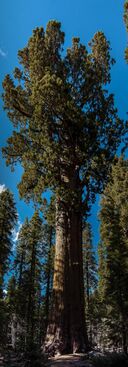
 A view of the General Sherman, the largest single stem tree in the world | |
| Lua error in Module:Location_map at line 522: Unable to find the specified location map definition: "Module:Location map/data/California" does not exist. | |
| Species | Giant sequoia (Sequoiadendron giganteum) |
| Coordinates | [ ⚑ ] 36°34′54″N 118°45′05.5″W / 36.58167°N 118.751528°W |
| Height | 83.8 m (275 ft) |
| Diameter | 7.7 m (25 ft) |
| Volume of trunk | 1,487 m3 (52,500 cu ft) |
| Date seeded | 700–300 BC |
Blank template
{{Infobox tree
| name=
| image=
| image_size=
| alt=
| image_caption=
| map=
| map_alt=
| map_size=
| map_caption=
| relief=
| label_position=
| map_image=
| native_name=
| native_name_lang=
| species=
| binomial=
| location=
| height=
| girth=
| diameter=
| volume=
| coordinates=<!-- {{coord|LAT|LON|type:landmark_region:XX|display=inline,title}} -->
| seeded=<!-- {{Start date|YYYY|MM|DD|df=y}} if after XXXX -->
| felled=<!-- {{End date|YYYY|MM|DD|df=y}} -->
| custodian=
| website=<!-- {{URL|example.com}}  -->
}}
TemplateData
TemplateData for Infobox tree
No description.
| Parameter | Description | Type | Status | |
|---|---|---|---|---|
| name | name | no description | Unknown | optional |
| image | image | no description | Unknown | optional |
| image_caption | image_caption | no description | Unknown | optional |
| image_size | image_size | no description | Unknown | optional |
| map | map | no description | Unknown | optional |
| map_size | map_size | no description | Unknown | optional |
| species | species | no description | Unknown | optional |
| binomial | binomial | no description | Unknown | optional |
| height | height | no description | Unknown | optional |
| diameter | diameter | no description | Unknown | optional |
| volume | volume | no description | Unknown | optional |
| seeded | seeded | no description
| Unknown | optional |
| relief | relief | no description | Unknown | optional |
| coordinates | coordinates | no description
| Unknown | optional |
| felled | felled | no description
| Unknown | optional |
| custodian | custodian | no description | Unknown | optional |
| website | website | no description
| Unknown | optional |
| map_alt | map_alt | no description | Unknown | optional |
| map_caption | map_caption | no description | Unknown | optional |
| alt | alt | no description | Unknown | optional |
| native_name | native_name | no description | Unknown | optional |
| native_name_lang | native_name_lang | no description | Unknown | optional |
| location | location | no description | Unknown | optional |
| girth | girth | no description | Unknown | optional |
| label | label | no description | Unknown | optional |
| label_position | label_position | no description | Unknown | optional |
| map_image | map_image | no description | Unknown | optional |
Microformats
The HTML markup produced by this template includes an hCard microformat, which makes the place-name and location parsable by computers, either acting automatically to catalogue articles across Wikipedia, or via a browser tool operated by a person, to (for example) add the subject to an address book. Within the hCard is a Geo microformat, which additionally makes the coordinates (latitude & longitude) parsable, so that they can be, say, looked up on a map, or downloaded to a GPS unit. For more information about the use of microformats on Wikipedia, please see the microformat project.
Sub-templates
If the place or venue has "established", "founded", "opened" or similar dates, use {{start date}} for the earliest of those dates unless the date is before 1583 CE.
If it has a URL, use {{URL}}.
Please do not remove instances of these sub-templates.
Classes
hCard uses HTML classes including:
- adr
- agent
- category
- county-name
- extended-address
- fn
- label
- locality
- nickname
- note
- org
- region
- street-address
- uid
- url
- vcard
Geo is produced by calling {{coord}}, and uses HTML classes:
- geo
- latitude
- longitude
Please do not rename or remove these classes nor collapse nested elements which use them.
Precision
When giving coordinates, please use an appropriate level of precision. Do not use {{coord}}'s |name= parameter.
This template emits a "species" (or "biota") microformat.
The microformat is created by the use of class="biota", and classes for individual taxonomic ranks, such as class="domain" in a span around {{{domain}}} (full list). Please do not change or remove those classes other than as part of development of the microformat. For background information, see microformats on Wikipedia and the microformat specification.
