File:Mapa języka litewskiego.tif
From HandWiki

Size of this preview of this TIF file: 800 × 593 pixels. Other resolution: 640 × 474 pixels.
Original file (5,303 × 3,930 pixels, file size: 1.38 MB, MIME type: image/tiff)
Summary
| Description |
English: Map of the areas where Lithuanian language was dominant, including language islands and mixed territories in the late 19 century by Polish linguist Jan Michał Rozwadowski (1867-1935), Kraków, 1930. |
| Date | |
| Source | https://archive.org/details/mapa-jezyka-litewskiego |
| Author | Rozwadowski, Jan Michał (1867-1935) |
Licensing
|
This work is in the public domain in its country of origin and other countries and areas where the copyright term is the author's life plus 70 years or fewer. This work is in the public domain in the United States because it was published (or registered with the U.S. Copyright Office) before January 1, 1929. | |
| This file has been identified as being free of known restrictions under copyright law, including all related and neighboring rights. | |
File history
Click on a date/time to view the file as it appeared at that time.
| Date/Time | Thumbnail | Dimensions | User | Comment | |
|---|---|---|---|---|---|
| current | 07:42, 11 March 2023 | 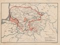 | 5,303 × 3,930 (1.38 MB) | imagescommonswiki>Žemėpatis | Uploaded a work by Rozwadowski, Jan Michał (1867-1935) from https://archive.org/details/mapa-jezyka-litewskiego with UploadWizard |
File usage
The following file is a duplicate of this file (more details):
- File:Mapa języka litewskiego.tif from Wikimedia Commons
The following 2 pages use this file:

