File:NASA Mars Subsurface Water Ice Mapping.png

Original file (2,219 × 1,297 pixels, file size: 2.47 MB, MIME type: image/png)
Summary
| Description |
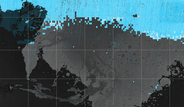
English: The blue areas on this map of Mars show regions where NASA missions have detected subsurface water ice. Scientists can use the map – part of the Subsurface Water Ice Mapping project, or SWIM – to decide where the first astronauts to set foot on the Red Planet should land. Triangles on the map are past and present Mars missions; circles are ice-exposing impact craters.
Mars has both water ice and carbon dioxide ice (dry ice); water ice would be a critical resource for the first astronauts to step foot on Mars, who can use it for drinking, rocket fuel, and other purposes. The more water ice these astronauts land next to, the less they need to bring with them. Because the Martian atmosphere is so thin – less than 1% the pressure experienced at sea level on Earth – liquid water is unstable on the Red Planet and will vaporize unless it’s frozen. But water ice on the planet’s surface is only stable at high latitudes that are far too cold for astronauts and robots to survive. So SWIM attempts to locate water ice preserved within the subsurface in the mid-latitudes, where landing would be feasible. Such regions are far enough toward the pole for water ice to be plentiful, but close enough to the equator to avoid the coldest temperatures seen on Mars. SWIM combines data from several NASA missions, including the Mars Reconnaissance Orbiter (MRO), 2001 Mars Odyssey, and the now-inactive Mars Global Surveyor. The project mapped the area from the equator to 60 degrees north latitude. SWIM is led by the Planetary Science Institute in Tucson, Arizona, and managed by NASA’s Jet Propulsion Laboratory in Southern California. The University of Arizona, in Tucson, operates HiRISE, which was built by Ball Aerospace & Technologies Corp., in Boulder, Colorado. JPL, a division of Caltech in Pasadena, California, manages MRO for NASA’s Science Mission Directorate in Washington. |
| Date | |
| Source | NASA |
| Author | NASA/JPL-Caltech/Planetary Science Institute |
Licensing
| This file is in the public domain in the United States because it was solely created by NASA. NASA copyright policy states that "NASA material is not protected by copyright unless noted". (See Template:PD-USGov, NASA copyright policy page or JPL Image Use Policy.) | ||
 |
Warnings:
|
File history
Click on a date/time to view the file as it appeared at that time.
| Date/Time | Thumbnail | Dimensions | User | Comment | |
|---|---|---|---|---|---|
| current | 17:21, 15 November 2023 | | 2,219 × 1,297 (2.47 MB) | imagescommonswiki>Liandrei | {{Information |Description= {{en|1=The blue areas on this map of Mars show regions where NASA missions have detected subsurface water ice. Scientists can use the map – part of the Subsurface Water Ice Mapping project, or SWIM – to decide where the first astronauts to set foot on the Red Planet should land. Triangles on the map are past and present Mars missions; circles are ice-exposing impact craters. Mars has both water ice and carbon dioxide ice (dry ice); water ice would be a critical re... |
File usage
The following file is a duplicate of this file (more details):
- File:NASA Mars Subsurface Water Ice Mapping.png from Wikimedia Commons
The following page uses this file:

