File:Darcha Padum Road Below Shinku La Lahaul Oct22 A7C 03533.jpg
From HandWiki

Size of this preview: 800 × 533 pixels. Other resolutions: 640 × 427 pixels | 6,000 × 4,000 pixels.
Original file (6,000 × 4,000 pixels, file size: 20.05 MB, MIME type: image/jpeg)
Summary
| Description |
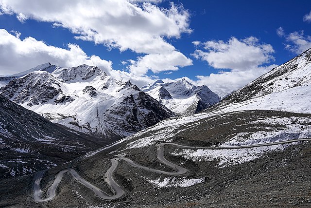
English: Darcha-Padum road winding up to Shinku La, Lahaul, Himachal, India. Elev. 4,975m (16,322'). Peaks about 5,600m (18,375').
Español: El sinuoso camino a Shingo La, un paso montañoso del Himalaya de 5090 m de altura en el norte de India, que conecta la región de Lahaul en Himachal Pradesh con la región de Zanskar en Ladakh.
Українська: Звивиста дорога до Шінго Ла, гімалайського гірського перевалу висотою 5091 м на півночі Індії, що з’єднує регіон Лахаул у Гімачал-Прадеші з регіоном Занскар у Ладакху. |
|||
| Date | ||||
| Source | Own work | |||
| Author |
|

| Camera location | | View this and other nearby images on: OpenStreetMap |
|---|
Assessment
|
This image was selected as picture of the day on Wikimedia Commons for 6 October 2023. It was captioned as follows: English: The winding road to Shingo La, a 5,090 m (16,700 ft) Himalayan mountain pass in northern India connecting the Lahaul region of Himachal Pradesh with the Zanskar region of Ladakh. Other languages:
Čeština: Klikatící se horská silnice k horskému přechodu Shingo La v nadmořské výšce 5 090 m n. m. v himálajské části severní Indie spojuje oblast Lahaul and Spiti district a Ladak. Deutsch: Die Straße zum Shingo La, einem 5.090 m hohen Gebirgspass im Himalaya. English: The winding road to Shingo La, a 5,090 m (16,700 ft) Himalayan mountain pass in northern India connecting the Lahaul region of Himachal Pradesh with the Zanskar region of Ladakh. Español: El sinuoso camino a Shingo La, un paso montañoso del Himalaya de 5090 m de altura en el norte de India, que conecta la región de Lahaul en Himachal Pradesh con la región de Zanskar en Ladakh. Français : Route sinueuse de l'Himalaya menant vers le passage de Shingo La situé à 5 090 m, et reliant le district de Lahaul et Spiti à Zanskar, en Inde. Magyar: Kanyargós út a Singo Lán, az 5090 méter magas himalájai hágón Észak-Indiában, amely a Himácsal Prades tartománybeli Lahaul régiót köti össze a ladaki Zanszkár régióval Nederlands: Haarspeldbochten in de weg naar Shingo La, een bergpas op 5090 meter hoogte die Lahul en Zanskar in het noorden van India met elkaar verbindt Português: Estrada sinuosa para Shingo La, uma passagem de 5 090 m na montanha do Himalaia, no norte da Índia, que conecta a região de Lahaul, em Himachal Pradesh, com a região de Zanskar, em Ladakh. Slovenščina: Vijugasta cesta do Šingo Laja, 5090 metrov visokega himalajskega gorskega prelaza na severu Indije, ki povezuje pokrajino Lahaul v Himačal Pradešu s pokrajino Zanskar v Ladaku. Українська: Звивиста дорога до Шінго Ла, гімалайського гірського перевалу висотою 5091 м на півночі Індії, що з’єднує регіон Лахаул у Гімачал-Прадеші з регіоном Занскар у Ладакху. বাংলা : উইন্ডিং রাস্তা থেকে লিঙ্গো লা, উত্তর ভারতের 5,090 m (16,700 ft) বিস্তৃত হিমালায়ন গিরিপথ, যা লাদাখের জান্সকার অঞ্চলের সাথে হিমাচল প্রদেশের লাহৌল অঞ্চলকে সংযুক্ত করেছে। |
Licensing
I, the copyright holder of this work, hereby publish it under the following license:
This file is licensed under the Creative Commons Attribution-Share Alike 4.0 International license.
- You are free:
- to share – to copy, distribute and transmit the work
- to remix – to adapt the work
- Under the following conditions:
- attribution – You must give appropriate credit, provide a link to the license, and indicate if changes were made. You may do so in any reasonable manner, but not in any way that suggests the licensor endorses you or your use.
- share alike – If you remix, transform, or build upon the material, you must distribute your contributions under the same or compatible license as the original.
File history
Click on a date/time to view the file as it appeared at that time.
| Date/Time | Thumbnail | Dimensions | User | Comment | |
|---|---|---|---|---|---|
| current | 00:07, 18 October 2022 | | 6,000 × 4,000 (20.05 MB) | imagescommonswiki>Tagooty | Uploaded own work with UploadWizard |
File usage
The following file is a duplicate of this file (more details):
- File:Darcha Padum Road Below Shinku La Lahaul Oct22 A7C 03533.jpg from Wikimedia Commons
The following page uses this file:

